- Congressional districts should be about the communities they represent, not statewide political considerations, and not splitting counties when redistricting keeps communities whole
- It is possible to use county groupings when drawing congressional districts
- A sample map demonstrates how using county groupings can help limit gerrymandering
Legislative Districts Should Be About Their Local Communities, Not Statewide Political Interests
Political boundaries often have meaning for the people who live in them. People have political, legal, and emotional attachments to counties and municipalities.
Municipalities and especially counties should be split as little as possible between districts. Likewise, large enough political communities should contain a whole district. In North Carolina, Mecklenburg and Wake counties should have congressional districts entirely within their borders (centered on Charlotte and Raleigh, respectively).
Those drawing congressional districts should not subsume those local interests with statewide political considerations that would warp the relationship between political communities and their chosen representatives. The most obvious of those considerations is gerrymandering by the party in power to maintain that power. However, it also includes attempts to satisfy statewide proportionality goals or make districts more competitive than they would be if drawn under neutral criteria.
The North Carolina Supreme Court ruled in Stephenson v. Bartlett (2002) that the state constitution requires that the General Assembly split as few counties as possible when drawing state legislative districts. The “Stephenson process” limits (but does not eliminate) legislators’ ability to gerrymander by reducing how creatively they can draw many districts. There is no similar requirement to minimize county splits in congressional districts.
As seen in Figure 1, Republicans are expected to win fewer than sixty percent of North Carolina House and Senate seats in the 2024 election but over seventy percent of congressional districts.
Figure 1: Average Republican Vote Share and the Expected Number of Republican Seats in the North Carolina House, Senate, and Congressional Delegation
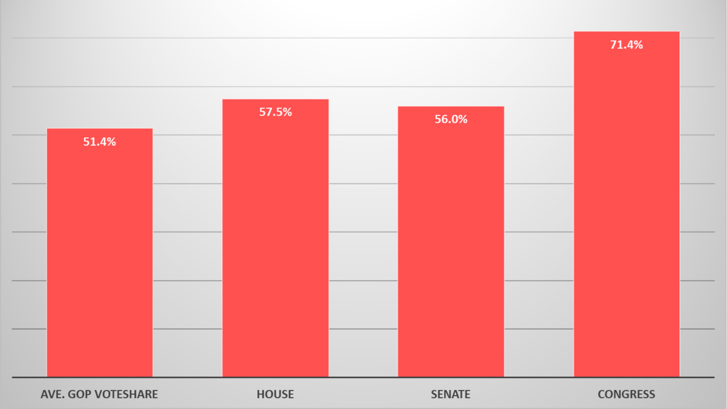
Data sources: the Civitas Partisan Index and analysis of congressional districts
In short, legislators’ ability to gerrymander should be constrained, and minimizing county splits is an effective tool for doing that.
There Can Be a “Stephenson Process” for Congressional Districts
We noted in Locke’s 2023 report, “Limiting Gerrymandering in North Carolina,” that the minimum number of county splits is one less than the number of districts in the state:
[W]hile there is no constitutional limit on how many counties can be traversed on a congressional map, a 13-county limit for the 14-district congressional map is reasonable.
We were not alone in determining that 13 county splits would be a reasonable limit for North Carolina’s 14-district congressional map. Analyses by Common Cause and expert testimony in a redistricting lawsuit reached the same conclusion.
It turns out that the limit on county splits could be even lower, as Austin Buchanan, an Associate Professor at Oklahoma State University, emailed to inform me (reprinted with permission):
[Y]ou can apply something like the Stephenson process to congressional districting and you can save some county splits (even when satisfying 1-person deviation). For example, it appears to me that North Carolina could draw a congressional plan with 11 county splits (and probably fewer).
Those findings are based on a paper he coauthored last December. He also provided a sample map with three congressional county groupings (Figure 2):
Figure 2: Three County Groupings with the Number of Congressional Districts in Each Grouping
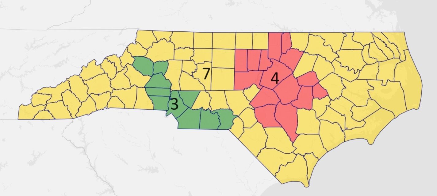
Source: Dr. Austin Buchanan
Buchanan requested I post these caveats if I publish his example:
- I am not suggesting that these county clusters should necessarily be used to draw districting plans in practice. My reason for sharing them is just to show that it is mathematically possible to have fewer than 13 county splits. Whether they lead to “good” or “legal” districts is a different question that I cannot answer with my optimization methods. [Locke’s redistricting report similarity notes “there are no optimal maps” that best follow all redistricting standards (such as compactness and not splitting too many municipalities).]
- I didn’t 100% follow the Stephenson process to get those three clusters, and it is quite possible (or even likely) that more than three clusters are possible (which would presumably lead to even fewer splits).
Drawing Districts Using Congressional County Groupings
Can map makers draw reasonable congressional districts using the county groupings Buchanan discovered?
As seen in Figure 3, the short answer is “yes.”
Figure 3: An Example of a Congressional District Map Based on the Three County Groupings
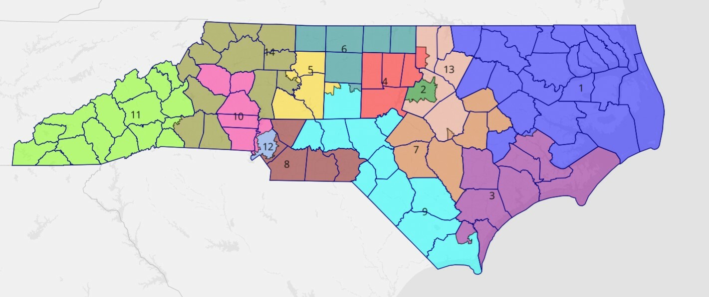
Drawn on Dave’s Redistricting
There are things not to like about this map. For example, districts 9 and 14 are not compact. The 14th District makes a hook across western North Carolina, while the 9th District runs from the southern Triad region all the way down to the coast. However, those strange shapes are due to fitting them within the county clusters, not for gerrymandering purposes.
That difference is reflected in the map’s overall partisan lean. As seen in Table 1, the map favors Republicans in seven districts and Democrats in four districts, with another three districts competitive (defined here as having a partisan lean of less than five percent). Without toss-up districts, the map is 8-6 Republican.
Table 1: Partisan Leanings of Districts Displayed in Figure 3
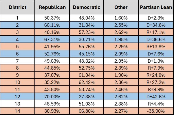
Data source: Dave’s Redistricting
While an 8-6 map would not satisfy either Republicans or Democrats, it would fit the findings of political scientist Dr. Jowei Chen. His work involving 1,000 computer-simulated North Carolina congressional maps using politically neutral criteria found that 9-5 and 8-6 Republican splits were much more common than any other outcome.
County Groupings Can Reduce Congressional Gerrymanders
A Stephenson-like county grouping process for congressional districts is not a “weird trick” that would, by itself, eliminate gerrymanders. It is a promising method that could split fewer counties than was once thought possible, keeping more political communities of interest together. It could also limit legislators’ ability to gerrymander congressional districts, just as the Stephenson process constrains their ability to gerrymander state legislative districts.
A congressional county grouping process is an intriguing idea worth exploring by those who favor redistricting reform.